

….. and our eyes met across the busy, crowded paddock … (I see ewe!).
NEW ZEALAND:THE MIDDLE PART OF OUR MIDDLE-EARTH ROAD TRIP
We love New Zealand! If you ask seasoned travellers what country has the best combination of breathtaking scenery, excellent wine (Pinot Noir from Central Otago? … Yes Please!), delicious food, smooth roads and dependable infrastructure in a safe, friendly & english-speaking environment, we reckon that the answer you’d hear the most would be New Zealand. That is a hard-to-beat combination.
There is just so much of interest packed into this small country that we couldn’t write about everything at once. So this slice of our trip will just cover the middle part of our Middle-Earth road trip.
The popularity of this remote country soared following the Lord of the Rings trilogy of films. The striking scenery suited the “Middle-Earth” described in the books of J.R.R. Tolkien so well that New Zealand itself is often referred to as Middle-Earth in tourist promotions.
The term “four seasons in one day” accurately describes the weather experience across these islands. We “experienced” quite a bit of unseasonal rain during our April-May visit to both the North and South Islands of this country. But we still enjoyed ourselves immensely. Oddly enough, the two regions we visited that are the wettest in the country – Fiordland and Southlands – showed us little but brilliant sun.
QUEENSTOWN: ADVENTURE CENTRAL
Our South Island Road Trip began in Queenstown, which is known as The Adventure Capital of New Zealand. Calling our trip an adventure is perhaps too ambitious since we strive to be comfortable. By definition, adventures suck while you’re having them. Usually only in the comfort of past tense are they truly enjoyable.
For those seeking adrenaline-charged pastimes, Queenstown is the place to be for high-octane fun. If you have money to spend, you can fill your days with skiing, bungee jumping, camping and hiking (“tramping”, in the local vernacular), biking, scenic flights, glacier landings, heli-skiing, white-water rafting, kayaking, jet-boating and much more. Just be prepared to enjoy your adventures in the rain, because it rains a lot! We shared our flight down with three hunters; one of them was ready for adventure in the extreme, travelling in head-to-toe camo, including his camo rubber boots!
All of this is based out of a small town situated on a steep hillside leading down to a lake, with the main road a slow procession of traffic (lots of tourist buses), snaking along the lakeside. There was a single alternative “back” road in and oddly enough, we found it empty when we used it while staying in nearby Arrowtown later in our trip (though it does add distance). It was a busy hub when Bruce visited the area 25 years ago and even though we weren’t there in any High Season, it was too packed-out for our liking.
The Queenstown International Airport is in an unbelievable picturesque location, by a lake and below the looming profile of the Remarkables Range. The approach on our flight from Auckland was terrifically scenic, following the Southern Alps along our route.
With so many direct overseas flights bringing in tourists visiting such a compact town, Queenstown was the only place we visited outside Auckland that we would call crowded. We were very happy to arrive, finding the airport small, but efficient. We ate a tasty meal and then strolled outside in the brisk sunshine to secure our rental car. Everything went smoothly, we loaded up and set off into…. a jam. We learned that the airport area, leading into town, is more often than not a big traffic bottleneck, causing serious slow-downs. We knew that the overwhelming popularity of Queenstown had created deplorably bad traffic, but we were just trying to head north without entering Queenstown proper.
Eventually we did get past the congested Frankton roundabout that every visitor to the area gets to know well and turned away from town. We then passed through the next three roundabouts in quick succession – each less clogged than the last. Then we shortly turned off onto the spectacular Crown Range Road, which hairpins up a steep hill and then winds down the long Cardrona Valley to the next significant town to the north, Wanaka, which is the “Queenstown for Kiwis”. A smaller, easier-to-manage tourist town, we really liked Wanaka.

The fence post that became a media sensation. The tall trees along the shore are actually more impressive, but they do not seem to get much attention from visitors to the beach.
#THATWANAKATREE
Wanaka boasts the most-photographed tree in New Zealand, which draws countless visitors. The town itself has a relaxed vibe and like many towns in the South Island Alps, is situated near ski hills in an attractive fashion beside a blue lake with jagged peaks in the distance. That Wanaka Tree, which is supposedly an old willow fence post, seems to be growing out of the lake. You can easily find stunning pictures of the tree online, but we found the tree high and dry.
Owing to a dry summer combined with local water use, the water level of the lake had dropped, leaving the tree above the waterline. So our pictures weren’t anything special, especially with cloudy skies preventing the requisite technicolour sunset, as well as the season only allowing a little bit of snow on just the highest peaks. From our room at Wanaka Heights overlooking the town we could see tripods of the tourists trying to get “That Shot” throughout the time we were there.
We could easily have stayed longer, but we picked Wanaka simply as an overnight stop allowing us to avoid expensive and overcrowded Queenstown.

The view from our room in the lakeside town of Wanaka
ON THE ROAD TO TEKAPO
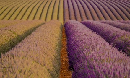
The next day we set off on a short drive, only three achingly panoramic hours continuing north-east through the Lindis Valley, crossing a vast dry rain shadow where the roadkill changed from possums to almost exclusively rabbits. The default “motor meat” one sees by the roadside in New Zealand are possums, but few tears are shed for them, being an unwelcome and destructive invasive species. Some drivers purposefully swerve to hit them, enthusiastically participating in the national program to eliminate pests.
Our destination was another bucolic lake town, a further downgrade in size, called Tekapo. The colour of Lake Tekapo is a more luminous blue hue than most of the competition and the looming mountains are even closer. If you have seen photos of fields of colourful lupin flowers alongside a brilliant blue lake, they were most likely taken in November in Tekapo. We missed the flowers as we visited in Fall, which offered a different palette of colours.

Driving through the dry Lindis Pass.
THE MT. JOHN EARTH & SKY TOUR
What is most notable about Tekapo is that it lies in a Dark Sky Reserve, which ensures that the area is outstanding for stargazing. In 2012, the government declared a 4300 square kilometer area the Aoraki Mackenzie International Dark Sky Reserve, with light pollution strictly controlled. It is the only one of its kind in the Southern Hemisphere, and one of only eight in the world. Within this reserve is New Zealand’s premier astronomical research centre, the Mount John Observatory. A nearby military camp that does live fire exercises determines that no planes fly overhead and the town itself has no traffic lights and minimal street lighting.
The Mt. John Observatory sits atop a hill overlooking the town and we signed up for their Earth & Sky stargazing tour at midnight that evening. They had an earlier tour, but it was sold out. We chose that night at the proverbial last minute (with the alternative being the following night) because clear skies were predicted. It turned out that we picked correctly, as the nights before and after ended up being clouded over. The skies were indeed spectacular, with no moon as a bonus.
But on arrival at the staging point from where they would transport us up the mountain, they informed us that a massive burn-off to the north had adversely affected the skies’ clarity. They offered full refunds as well as the option for shortening the trip and getting a partial refund. Some of the group cancelled and the rest voted to keep going, but shorten the trip.
We were offered puffy parkas that had been used in Antarctica. Max & Fung opted for the huge jackets while Bruce decided to rely on his four layers and Canadian blood. Once up at the observatory, they were thankful for the extra insulation and Bruce was OK, though he’d admit that it was “nippy”. That said, one of our two guides was only wearing a t-shirt! They get used to it, we reckon.
On the half-hour drive from Tekapo, we left the main road, crossed a private farm and then heading up a sinuous road through the dry, barren terrain, sighting plenty of rabbits by the roadside. Then, on our final approach, the driver informed us that he had to turn off the headlights in order to not disturb work going on in the observatory. That got everyone’s attention as we continued to wind up a steep road with a substantial drop-off to one side. So the driver navigating by starlight for the final few hundred meters, carrying a bus-load of passengers buried in their parkas, holding their collective breath. Exciting.
We made it, of course. Then stepped off the mini-bus and immediately noticed the big drop in temperature. Cold and crisp! We reckoned it was around 10˚C or less. Balmy to some, but not us equatorial types.
Because there were no planes, the two guides (one Canadian and one English) could use super-powerful laser pointers to point out celestial bodies of interest. Their talk was interesting, informative and we looked through their two telescopes at Jupiter and its moons along with Saturn and other cool celestial bodies. We were assured that the images were well below par owing to haze in the sky to the north. But even with distant burning, the sky seemed clear to us and if we return to Tekapo, we’d love to go back to do it again.
So we enthusiastically recommended the Mt. John Earth & Sky Tour, but you need to book ahead and it must be truly frigid up there in wintertime, so dress accordingly.
THE CHURCH OF THE GOOD SHEPHERD

On our return, just after 2:00 am, we popped over to a stone church just outside town that is a popular photo-stop.
The Church of the Good Shepherd with the starry sky above it would be an exceptional picture opportunity and going there so late must ensure there was no competition, right?
Wrong! Even at 2:30 am it was crawling with a dozen or so Chinese shutterbugs, trying to move their tripods around in the dark. But every now and then someone would use their hand phone light to see what they were doing, affecting the time-lapse efforts of others, who would whisper angrily at the offending party. It isn’t easy to play with your settings and frame your picture by starlight, but we think we got a few decent results in the end.
Left: The Church of the Good Shepherd in Tekapo under the Milky Way.
AORAKI / MT. COOK

Following the shoreline of the brilliant-blue Lake Pukaki towards Aoraki.
The next day, still based in Tekapo at the Lake Tekapo Village Motel, we doubled-back the way we came from Wanaka and made a side trip to Mt. Cook (Aoraki), the tallest peak in NZ. The drive along the lake was relentlessly picturesque, something we could say about almost all of our drives around New Zealand, even though moving clouds limited clear views of the peak and the winds coming off the Southern Alps picked up as we neared the end of the road.


Impressive Middle-Earth scenery on the way to Aoraki.
We planned to park and enjoy the (of course) scenic and easy walk that approaches Mt Cook, but the fast-changing weather had other plans for us. Simply getting out of the car took effort, working against gusts strong enough to slam the doors closed once we were out of the car. Tents in the adjacent camping area were being picked up and tossed away, with owners (at least those present) giving chase and grappling with their pinwheeling camping gear. We noticed determined Chinese families bundling up their kids and setting off on the trail, bent over into the wind. We’re not that tough, so took a look around, made use of the plumbing in the visitor’s centre, then drove back the way we came.
On our way back along the lake we passed a Chinese bride and her photographer stranded on their own by the roadside. This was just one of countless Chinese pre-wedding photoshoots we passed in progress during our travels throughout New Zealand, but especially on the South Island. In fact, there were enough of them that they lost their strangeness over time and eventually seemed a common, if incongruent occurrence and just part of the scenery, like deer farms.


The road to Aoraki (left); a bellowing red deer male (the antlers have been sawn off) bellowing over his “harem” in a roadside deer farm (right).
DISTANCE & COLOUR
The next day was one of two long driving days (~6 hrs) on our itinerary. In New Zealand one quickly learns that drives always take longer than planned. Distances don’t look far, but it seems like a kilometer anywhere else translated to 1.5 km in New Zealand. It was odd that way. You read the distance noted on the signs and mentally calculate how long it takes, taking into account your average speed. But in reality it takes longer than any projection we ever came up with.
Not all roads were winding through mountain passes. Many roads were flat and relatively straight, traffic was light and we often encountered cars every ten minutes only in many stretches. Passing was easy. There were few traffic lights, substituted with more roundabouts than we’ve ever encountered in total everywhere else we’ve ever been. The one-lane bridges, of which there were more than two-lane bridges throughout the countryside, did slow you down now and then, but not by much. We usually stopped to wait for only a single car to use the bridge in our direction. The speed limits were reasonable and we only noticed speeding (more than 20 km above the posted limit) at night or early in the morning. So why everything took longer was a cause of puzzlement.
Most cars were either white or silver, the opposite of the default fashion colour, which was black. On the west coast of Canada, wearing colour was also rare, with earth tones and grey-to-black being seemingly the way to fit in. In New Zealand it was darker. Black. Just like the All Blacks. Johnny Cash would have been right at home. Roy Orbison would have also fit right in. Black, but not the cars.

Roadside rainshadow scenery on the road towards Tekapo.
ACROSS THE SOUTHERN ALPS TO PANCAKE ROCKS
So we set off from Tekapo, having a quick last look at The Church of the Good Shepherd, sharing the place with two or three tour buses, mostly Chinese, including the ubiquitous wedding party posing for pictures. Then we did what we enjoyed most, cruising on easy roads through bucolic pastoral settings. We had lunch in a cafe in Geraldine, then headed north through farmland as the accompanying autumn rain grew into downpours. Further along we joined the east-west road that climbed through the Alps, crossing over at Arthur’s Pass, where Bruce remembered overnighting on his earlier trip, soaking in a hot tub at night as the Spring snow fell.


The Otira Viaduct in Arthur’s Pass (left); Verdant Paparoa National Park vegetation (right)
After Arthur’s Pass, the road dropped down to the wild west coast, with waves crashing on jagged offshore rocks and dense tropical vegetation climbing up the steep, deeply-ravined slopes of the coastal mountains. On reaching the ocean, we headed north past the town of Greymouth into the Paparoa National Park.
Our destination was Punakaiki, famous for the Pancake Rocks – rock formations that looked like… obviously,.. stacked pancakes. We spent the night in a fabulous high-ceilinged log cabin with an ocean view at the Paparoa Park Motel & Cottages.
There’s no real town there, so we knew to bring food to cook. The scenery was spectacular and there was interesting vegetation we didn’t see further south, including the iconic nikau palm. We wished we stayed longer in that area as it was unexpectedly alluring.

The view from our accomodation past Punakaiki towards Pancake Rocks at the next point (top); Looking from Pancake Rocks southward, with our accomodation on the next point – a reverse view of the photo above (bottom).


left to right: Fung on the immaculate walkway to the Pancake Rocks; the famous Pancake Rocks; Nikau palms, which are common in the area.
THE KIWI UTILITARIAN MINDSET
After our one night in Punakaiki we toured the Pancake Rocks (highly recommended) just up the road and then double-backed south along the coast, passing once more through Greymouth.
This town was somewhat distinctive to us as we noticed some “nice houses”. Most of the houses in New Zealand can exclusively be described as bland. Only Queenstown also had houses we deemed worthy of a second look. Most communities consisted of simple houses covered in wooden siding (“weatherboard” to them, “clapboard” to most Canadians). They probably feel that wooden houses are more earthquake-proof, which we can agree with, living in an earthquake-prone region ourselves and seeing all the cracks in the cement walls. Pictures from 100 years ago showed exactly the same style of dwellings. In a country boasting so much natural beauty, it is surprising how utilitarian the housing is.
Bruce understands how being a Kiwi is not different from being a Canadian: folks are polite, work hard and try to not attract too much attention. In their actions and dress it seems bad form to show off. A friend in Auckland told us that few houses had their own well simply because it would seem ostentatious.
Most homes didn’t even have central heating. They seem slow to modernize. We were warned that New Zealand had the slowest internet of any developed country, but they must have worked on it, because other than in remote Franz Josef, we found the internet to be fast enough for our liking.

Spectacular South Island scenery along the west coast near Punakaiki.
SOUTHBOUND & BACK ACROSS
After around three hours of admiring the passing coastal scenery, we arrived in the town of Franz Josef, made famous by the nearby Franz Josef Glacier. It was a bit of a walk from the parking lot to reach to dirty terminus of the glacier twenty-five years earlier when Bruce previously visited the area. Even though the parking lot had been moved closer to the glacier in recent years, we were told to expect a 1.5-hr walk to the glacier owing to the rapid retreat of the glacier. So we decided to give it a miss, feeling lazy.
But we did get out that evening to see glow worms along a pathway only minutes from our room at the Terrace Motel, along with numerous crayfish in a stream, which was cool. Franz Josef, like many popular tourist towns in New Zealand, have myriad options of things to do and see, with plenty of freely available tourist information. But we were only staying a single night.
We ate our dinner out that night, even though our motel room had a kitchen. Finding hotel rooms with kitchenettes in New Zealand is a lot more easy than in Europe. We had managed to book almost all of our hotel rooms to include a kitchen, which is a popular option in a country where dining out is pricey. Getting take-away or just picking up staples to cook was straightforward, with the major grocery outlets Pak’nSave, Countdown and New World unmissable along our route. Enjoying restaurants was something we did when feeling lazy or tired from driving. Whatever our choice, the food was all good.


The forested road (left) to the Fox Glacier (right). Love the tree ferns.
The next day, our second long driving day (~9 hours), we drove (mostly) inland from the coast continuing south after stopping for a yummy brunch at the next glacier town – Fox Glacier. We took a side trip from the main road to drive up far enough to see the glacier, then continued through Bruce Bay and eventually turned inland to climb through the Haast Pass. This route brought us back to Wanaka, where we had been less than a week earlier.
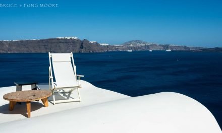
Having completed our circular route we maintained our forward momentum. We retraced our earlier route, but continued driving right past the Queenstown Airport as we kept heading south. We followed the eastern edge of Lake Wakatipu, enjoying the late afternoon light along the winding road known as The Devil’s Staircase. Then we turned west back out to the coast as darkness fell, heading to Manapouri. There we would settle in for three nights, comfortably based at Acheron Cottages as we explored the spectacular Fiordlands.


Clockwise from upper left: The Crown Range Road dropping towards Queenstown (seen in the distance); The Devil’s Staircase; Rush Hour, Kiwi-style alongside the Crown Range Road.


